'Bigger Than The City Of Denver': Bobcat Fire Shows No Signs Of Slowing As New Evac Orders Issued
LATEST EVACUATIONS AND CLOSURES
MONROVIA (CBSLA) – The Bobcat Fire -- now one of the largest in Los Angeles County history -- showed no signs of easing up Monday as it continues to threaten the Antelope Valley, where it has burned homes and forced thousands of people to flee.
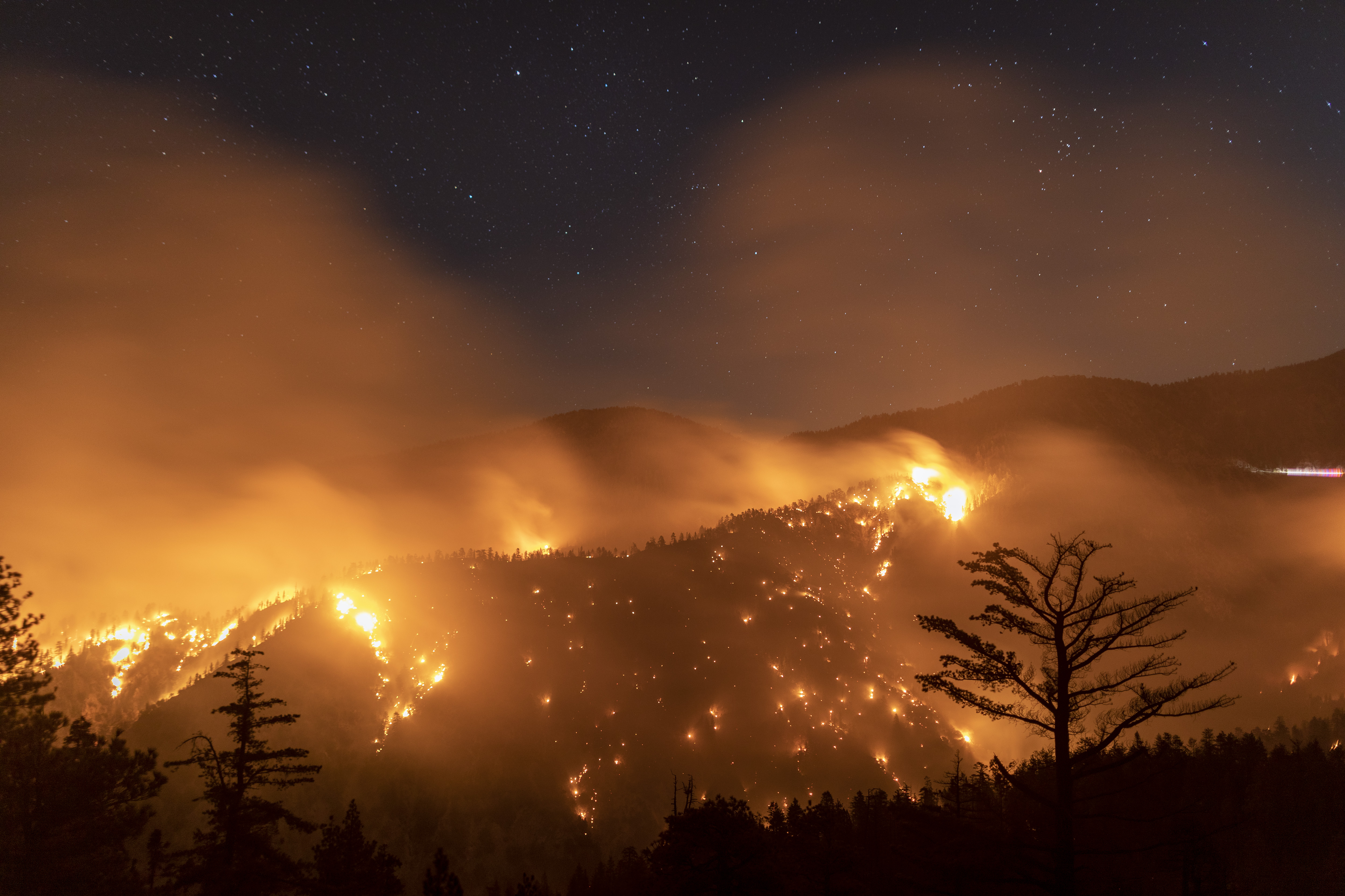
As of Monday night, the fire was 106,179 acres in size and containment decreased from 15% to 13%, with strengthening winds a growing concern.
"We've got a fire here that is bigger than the city of Denver, and it did it in two weeks," said Sky Cornell with the L.A. County Fire Department Monday.
Winds continued to fan the flames as officials warned that the north end of the fire would continue to spread from the Antelope Valley foothills into the communities of Juniper Hills, Valyermo and Big Pine.
New evacuation orders were also issued Monday afternoon for residents south and west of Upper Big Tujunga Canyon Road; east of Angeles Forest Highway; and north of Angeles Crest (2) Highway.
The fire was most active around Mount Wilson, Chilao and Little Rock Creek as of late Monday morning.
"On the northern end of the fire's perimeter towards Antelope Valley, firefighters are constructing both direct and indirect line to stop the fire from spreading to the east and west," the U.S. Forest Service reported Monday on its incident information page.
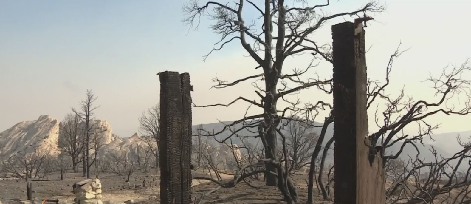
At least 29 homes have burned due to the Bobcat Fire, although L.A. County Fire says the number could still increase. The Nature Center in the Devil's Punchbowl Natural Area was also destroyed.
"We do know that we lost homes, we're working on trying to assess how many," Cornell said.
L.A. County will host a virtual community meeting Monday on the YouTube channel it has set up specifically about the Bobcat Fire. The webcast is scheduled for 6:30 p.m.
Firefighters continued, meanwhile, to defend the Mount Wilson Observatory in the Angeles National Forest along with several radio and television communication towers valued at about $1 billion. Crews have been stationed around the Observatory for several days as flames continue to creep dangerously close, at one point getting within 500 feet. Crews Monday were working frantically to put out spot fires to the north of the Observatory.
"Mt. Wilson was a high priority for us all day. That's actually been a priority for the last few days," Cornell said. "We know that our crews worked heavy last night into today and will continue to do that through the night. We've been able to take advantage of our air resources... and also our ground crews."
More than 1,500 personnel are battling the Bobcat Fire with the help of water-dropping helicopters and retardant-dropping air tankers.
"Air attack is huge for us," Cornell said late Sunday night. "When you've got terrain that is this steep and so difficult to get to, nearly impossible in some areas because it's just too dangerous to have our firefighters go across that steep of terrain, air attack is the key and it's the answer. So that air attack will continue day and night until this fire's out."
Crews have made progress on the southern edge of the fire, with evacuation warnings lifted over the weekend for several San Gabriel Valley foothill communities.
A Red Cross evacuation point has been set up at Palmdale High School in the Antelope Valley, while the earlier evacuation point at Santa Anita Park for those in the San Gabriel Valley was closed. Evacuees are being given vouchers to nearby hotels due to the coronavirus pandemic.
All 18 national forests in California remain closed to the public, including the Angeles National Forest.
Smoky and unhealthy air will continue to be a problem for the Southland. The South Coast Air Quality Management District extended its smoke advisory through Monday, with officials warning that "smoke may impact different parts of the region at different times."
The Bobcat Fire broke out a little after noon on Sept. 6 amid triple-digit temperatures near the Cogswell Dam and the West Fork Day Use area. The fire is churning through thick vegetation and dry brush in steep terrain, some of which has not burned in more 60 years.
The cause is under investigation.
Statewide, there are at least 26 fatalities so far due to the wildfires burning across California and at least 6,400 structures destroyed. Over 23,000 people are currently evacuated from their homes. The fires have burned more than 3.6 million acres so far this year.
Evacuation Orders:
- South and West of Upper Big Tujunga
- East of Angeles Forest Hwy
- North of Angeles Crest Hwy
- Residences along Angeles Crest Highway, between Angeles Forest Highway and Highway 39
- The unincorporated areas of Juniper Hills, Devils Punch Bowl, and Paradise Springs
- The unincorporated areas of Crystal Lake, East Fork of the San Gabriel River, and Camp Williams
- South of Hwy 138, North of Big Rock Creek, East of 87th St East, and West of Largo Vista Rd
- South of 138th St. East, North of Big Pine Hwy and Hwy 2, East of Largo Vista Rd., and West of 263rd St. East
- South of Hwy 138, North of East Ave W-14, East of 155th St East, and West of 165th St. East
Evacuation Warnings:
- City of Pasadena
- Unincorporated communities of Altadena and Wrightwood
- South of Pearblossom Hwy, East and North of Angeles Forest Hwy, North and West of Mt. Emma Rd., East and South of Hwy 122, and West of Cheseboro Rd
- South of Hwy 2, North of Blue Ridge Truck Trail, East of Hwy 39, and West of the Los Angeles Co. border
- South of Ave U-8, North of East Ave W-14, East of 121st East, and West of 155th St East (Longview)
- South of Pearblossom Hwy (Hwy 138), South and East of Pearblossom Hwy (Hwy 122), North and West of Mt. Emma Rd., North and East of Angeles Forest Hwy, and West of Cheseboro Rd. (Emma)
- South of Mt. Emma Rd., North of Upper Big Tujunga Canyon Rd., East of Angeles Forest Highway, and West of Pacifico Mountain
- Littlerock: East of Cheseboro Road, South of Pearblossom Hwy, North of Weber Ranch Rd, West of 87th St E.
A Red Cross Evacuation Center has been established at Palmdale High School, located at 2137 E Avenue R, Palmdale, 93550. The first evacuation point at Santa Anita Park is now closed and anyone still needing assistance is asked to call the Disaster Distress Hotline at 800-675-5799. Large animals can be evacuated to the Antelope Valley Fairgrounds at 2551 W Avenue H, Lancaster, CA 93536.
Check the incident management website and L.A. County Sheriff's Department Twitter for ongoing evacuation updates.
(© Copyright 2020 CBS Broadcasting Inc. All Rights Reserved. City News Service contributed to this report.)