Thomas Fire: Latest Closures And Evacuations
SANTA BARBARA (CBSLA) — The Thomas fire, now the largest in California's history, entered its 14th day Sunday at 45 percent containment. Below is the latest information on evacuations.

MANDATORY EVACUATION ORDERS | SANTA BARBARA COUNTY
Below are mandatory evacuation orders for Santa Barbara County issued by the Sheriff's Department as of Saturday, Dec. 16, 2017:
• All areas east of Highway 154, south of East Camino Cielo, west of Toro Canyon and north of Highway 101 at Toro Canyon to South Salinas then north of Alameda Padre Serra and to Highway 192 west to 154.
• The previous evacuation order for the area east of Toro Canyon to Casitas Pass Road north of Highway 192 and south of East Camino Cielo remains in effect. Residents should leave immediately.
VOLUNTARY EVACUATION ORDERS | SANTA BARBARA COUNTY
Below are current voluntary evacuation warnings for Santa Barbara County issued by the Sheriff's Department as of Saturday, Dec. 16, 2017:
• Painted Cave community includes the area north of Hwy 154 and south of East Camino Cielo along Painted Cave Road. If you are in this area, be prepared to leave.
• East of and including North San Marcos Road to Highway 154, north of Cathedral Oaks and south of the intersection of Highway 154 and N. San Marcos Road (near top of San Marcos Pass).
• South of Highway 192, west of N. San Marcos Road, north of State Street, and east of Nomad Village/San Vicente Mobile Home Park, including La Cumbre Road and Hope Avenue south of State Street to Highway 101.
• East of Mission Street/Los Olivos, north of Highway 101 and south of Salinas/Alameda Padre Serra.
• In the Montecito area, south of 101 to the ocean and east of the Zoo/Ninos Drive to Eucalyptus Lane
EVACUATION CENTER AND RESOURCES | SANTA BARBARA COUNTY
• An evacuation shelter has been established at the UCSB Recreational Center, 516 Ocean Road, Santa Barbara, 93106.
• Animal evacuation centers are available for residents in evacuation zones. Please contactthe Animal Services hotline at (805) 681-4332 to coordinate the sheltering and care of large and small animals.
• To receive emergency alerts, go to www.AwareAndPrepare.org.
• For ongoing updates, go to www.CountyofSB.org, follow @countyofsb on Twitter and Facebook, or call 2-1-1 from 805 area code, or 800-400-1572 outside of 805.
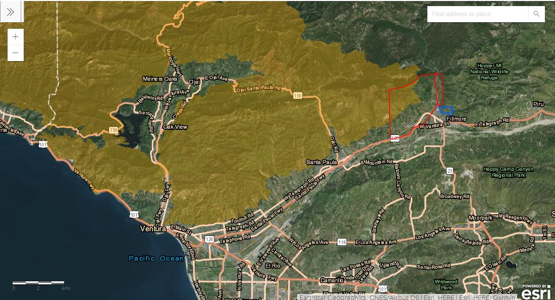
MANDATORY EVACUATION ORDERS | VENTURA COUNTY
Below are mandatory evacuation orders for Ventura County updated as of Saturday, Dec. 16, 2017:
• Unincorporated Ventura County Area
• Residents and day visitors of Rose Valley
• Unincorporated area of Fillmore (Alert was re-issued as a reminder on 12/14 at 9:10 AM)
• The area of Hall Road east, Sespe Creek to the east, Fillmore City limits to the south, and Los Padres National Forest boundary to the north Sespe Creek to the west, Burson Ranch to the east, Fillmore City limits to the south, and Los Padres National Forest boundary to the north. (Added 12/14 at 6:25)
There are no voluntary evacuation orders currently in effect for Ventura County.
HARD ROAD CLOSURES | VENTURA COUNTY
• SR 33 is again CLOSED from Fairview Ave, Ojai to Ventucopa.
• Old Telegraph Road at 7th Street
• Old Telegraph Road at SR 126
• Old Telegraph at Cliff Road
• Goodenough Road at Ash (no northbound traffic on Goodenough)
• Sycamore Road at SR 126
EVACUATION CENTER AND RESOURCES | VENTURA COUNTY
• Ventura County Fairgrounds – 10 W Harbor Blvd, Ventura;
• UCSB Recreational Center (Includes an Animal Shelter for small animals - preferably in crates) 516 Ocean Road, Santa Barbara;
• For all school closure updates, visit http://www.vcoe.org/.