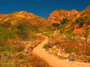
Best Hiking Trails in Orange County

(credit: Thomas Barrat/shutterstock)
One of the great things about living in Orange County is being blessed with some of the most beautiful weather year-round. While it is easy to celebrate the glorious warming glow of the SoCal sun by indulging in easily accessible, highly visible options like the beaches of Disneyland, those looking to really get in touch with the rustic, natural side of Orange County will head to the hills and take a hike on one of the county's vast, underrated network of trails. Nestled in the canyons, slopes, and mountains that make up a surprisingly large chunk of the region, these meticulously kept paths of varying difficulty show a naturally breathtaking side of Orange County that is easy to forget about when you are entrenched in the midst of a cubicle farm.If you have never been on a hike through Orange County's web of trails, here are a few essential paths to check out. These carved routes will most certainly allow you to get in touch with OC in a unique, refreshingly rustic way.
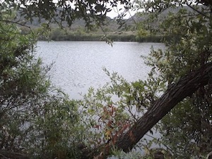
Barbara's Lake Loop Trail
18751 Laguna Canyon Road
Laguna Beach, CA 92651
Located within the confines of the James F. Dilley preserve inside the Laguna Canyon Wilderness Park, this 2.7 mile long loop trail will get you up close and personal with the only natural lake to be found in Orange County; a stunning 12 acre spring-fed body of water surrounded by indigenous plant life and populated by various waterfowl. Its beauty may make it tough for you to comprehend that the Irvine Spectrum is a mere ten minutes away.
Directions: Take the 5 or 405 South to the 133 and head south until it turns into Laguna Canyon Road. Make a U-Turn when you reach the on-ramp to the 73 Toll Road. The Parking Lot to the Dilley Preserve and the trail will be on the right hand side.
Laurel Canyon Loop Trail
18751 Laguna Canyon Road
Laguna Beach, CA 92651
This 3.5 mile long loop trail, located just down the road from the Barbara's Lake Loop in the Laguna Canyon Wilderness Park, will wind its way past bright floral growth and jagged rock formations as it makes a slow ascent to a canyon peak. One at the top, trail opens up to a brilliant panoramic view of the surrounding coastal canyon.
Directions: Take the 5 or the 405 to the 133, and head south until it turns into Laguna Canyon Road. The entrance to the trail will be on the right side, after you go under the 73 Toll Road and pass the El Toro Road intersection.
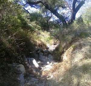
Black Star Canyon Falls Trail
Checking in at 13.2 miles round trip, this is arguably the best OC hike to take during the rainy season. Doing so will give you the best shot at seeing Orange County's most breathtaking waterfall; a tumbling cascade of water created by a combination natural rock formations and the remains of an old mine shaft. But even if you take the trek during the dry part of the calendar year, the route will still give you plenty of stuff to see, from natural brush and forestry to random artifacts of human civilization, like an abandoned school bus.
Directions: From the 55 Freeway, take the Champman Ave. exit and head east until you get into the canyons. You will hang a left of Silverado, just past Irvine Lake, and then take a quick left onto Black Star Canyon Road. The parking area is located at the trailhead about a mile up the street.
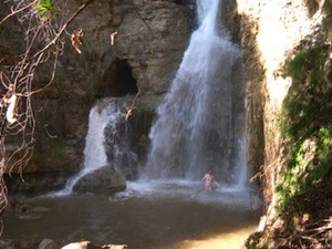
Holy Jim Falls Trail
Arguably the most popular trail for family hiking, this 2.8 mile round trip is an essential jaunt because it is steeped in history; its trailhead marks the place where the last wild California Grizzly bear was shot. While the drive up to the trail can be tricky especially after a good hard rain, the payoff for the journey is measured in the form of brush, wild animals, a trout-stocked creek, and a majestic waterfall at the route's end.
Directions: Take the 55 to the Chapman exit and head east into the foothills. From there, take a left on Live Oak Canyon Road (you will see the biker bar Cook's Corner on the intersection). Next, you will take a left into the dirt road just past Trabuco Creek and continue for about 4.5 miles to the trail's parking lot. NOTE: Trucks are recommended to drive to the trailhead, although some people will park at the start of the dirt road and the path's additional length to the hike.

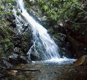
Trabuco Canyon Trail
Right next to the start of the Holy Jim trail stands this lengthier pathway, whose round trip distance checks in at 5.2 miles. Links to the foothills' days as a mining colony still pepper this trail of dense woods and deep forest growth. The most famous of these special artifacts is an old mine car that stands at the mouth of abandoned gold mine; if you hit this road at the right time of year, you will most likely see a flood of salamanders hanging around this historic equipment.
Directions: Take the 55 to the Chapman exit and head east into the foothills. From there, take a left on Live Oak Canyon Road (you will see the biker bar Cook's Corner on the intersection). Next, you will take a left into the dirt road just past Trabuco Creek and continue for about 4.5 miles to the trail's parking lot. NOTE: Trucks are recommended to drive to the trailhead, although some people will park at the start of the dirt road and the path's additional length to the hike.
Borrego Trail/Red Rock Trail
Foothill RanchDon't let the fact that this 8 mile round trip trail starts in the midst of South County suburbia fool you. Once you embark from the Borrego trailhead, you will be lead to the Red Rock Trail, which will lead you into Red Rock Canyon. Equipped with beautiful sandstone cliffs marked with brilliant red hues that shift in shade as the sunlight angles change, the layers of sand and mud exposed on the cropped stones serves as a fascinating study of erosion in action.
How to Get There: Take the 5 or 405 to Bake Parkway and head east. Go about 5.5 miles, then take a left on Portola Parkway. Next, take a right at Market Place, then a left into the parking lot.
Peters Canyon Lake View Trail
8548 E. Canyon View Ave.
Orange, CA 92869
The name says it all when it comes to this 2.6 miles long loop trail. It is located in Peters Canyon Regional Park, and its path passes by a massive, 55-acre reservoir. Even though the body of water is technically artificial, there is plenty of nature to enjoy on this route, ranging from a running creek and a freshwater marsh to scores of birds and waterfowl to observe.
How to Get There: Take the 55 Freeway to Chapman Avenue and head east. From there, take a right on Jamboree Road, then take a left onto Canyon View Lane. The parking lot for the park and the trail will be on the left.