Rain Falls Across Southland, Sparks Risk Of Flash Flooding In Burn Areas
MONROVIA (CBSLA) – Many Angelenos woke up to unusual summer rainfall Monday, as forecasters warned of the risk of flash flooding throughout the day across the Southland, especially in burn areas.
A flash flood watch was in effect through 8 p.m. Monday for Los Angeles County mountain areas including Lancaster, El Monte, East Los Angeles, Topatopa Peak, Reyes Peak, West Covina, Alhambra, Falling Springs, Pasadena, Pomona, Palmdale and Whittier.
Excluded from the flood watch was the Santa Monica Mountains, the San Gabriel Valley and the Ventura County Mountains.
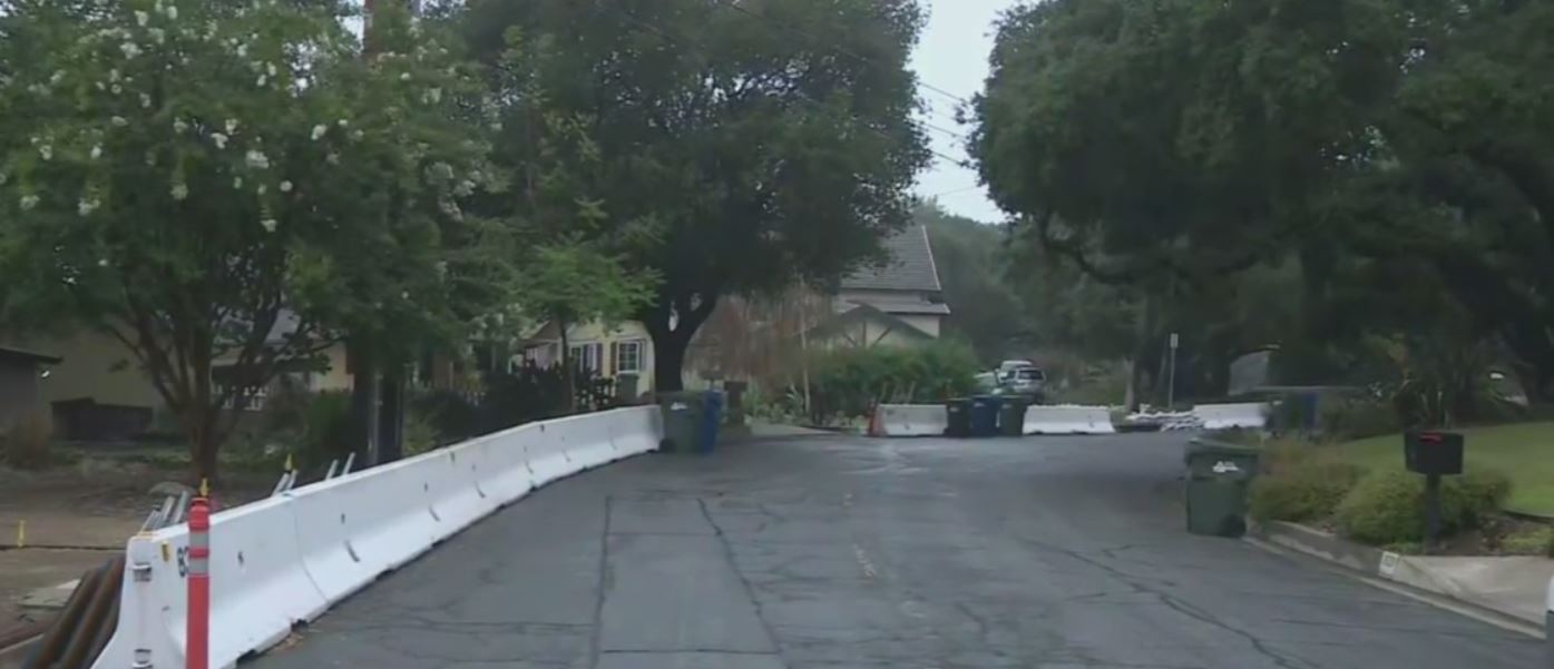
K-rails are in place in a Monrovia neighborhood to protect homes below the Bobcat Fire burn scar. The K-rails are expected to remain in place for about five years.
Shortly after the Bobcat Fire, geological experts mapped the areas within its burn scar most likely to break apart and rush down during a rainstorm. Their marking showed the most fragile earth was located above Monrovia.
Nearby, the tapping of raindrops awoke Sierra Madre residents Carol Handley
"It was just pouring rain and I thought, 'Oh, this is really great,' but then I thought, 'Oh, I hope it doesn't pour for a long time because the ground can't absorb that much water at one time.'"
"Scattered showers and thunderstorms, some capable of producing heavy downpours with rainfall rates up to an inch per hour are possible," the National Weather Service wrote.
A storm cell moving through the region could bring heavy rain that causes flash flooding and debris flows in burn areas, the NWS said, including the burn scars of the Bobcat Fire in the Antelope Valley foothills, the Dam Fire in the Angeles National Forest north of Azusa, the arson-sparked Ranch Fire north of Azusa and the Lake Fire near Lake Hughes.
There's also the risk of flash flooding for neighborhoods below the El Dorado Fire burn scar in Yucaipa in San Bernardino County. Evacuation warnings were issued by Cal Fire from 8 a.m. to 8 p.m. Monday.
Meanwhile, downtown L.A. Monday shattered a daily record for rainfall on this date. So far, it has received 0.12 inches of rain, breaking the daily record of 0.04 inches set back on this day in 2013.
So far this month, Downtown L.A. has received 0.22 inches or rain, making it the third wettest July since records began 1877, CBS2 Meteorologist Amber Lee reports.
The wettest July occurred in 2015, when downtown L.A. received 0.38 inches of rain. The second wettest July was 1886, with 0.24 inches.
Jacqueline Cochran Regional Airport in the Riverside County community of Thermal reported 0.42 inches of rain Monday alone, according to NWS. That is more than rain than the total rainfall between Jan. 1 and July 25, when the airport recorded 0.31 inches of rain.