Satellite Images Of Angeles National Forest Show Effects Of Drought In Just 1 Year
ANGELES NATIONAL FOREST (CBSLA) — New satellite images of the Angeles National Forest show just how fast the drought has taken a toll on the region's forests and reservoirs.
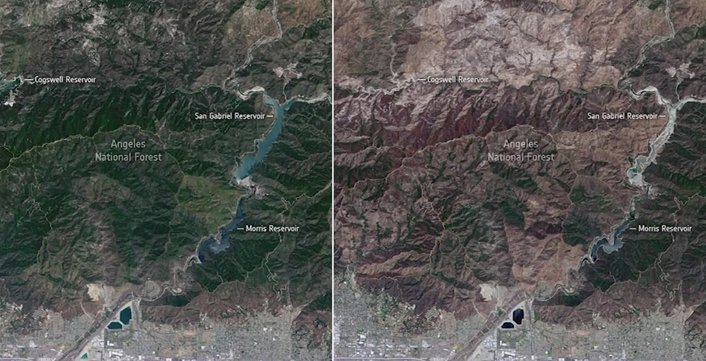
The European Space Agency released images taken on June 22, 2020 and June 12, 2021 of the Angeles National Forest and the San Gabriel Reservoir.
The 2020 satellite image shows a mostly green forest, right above Azusa, and the Morris, San Gabriel and Cogswell reservoirs appear bright blue with water. But just a year later, the same area shows varying shades of brown and almost white. The green areas that remain are mostly east of the Morris Reservoirs, which now appears to be a dimmer shade of blue, indicating lower levels of water.
The San Gabriel and Cogswell reservoirs both appear almost completely dry in the satellite image.
"The difference is clear to see, not only is the Angeles National Forest brown and at high risk of fire compared to the lush green of last year, but water in the reservoirs is severely depleted," the ESA wrote in a Facebook post. "In fact, the reservoirs are about 50% lower than they should be at this time of year, and the San Gabriel reservoir is almost dry."
More than 85% of the state is already in severe drought conditions, with 33% of the state classified as being in exceptional drought. Gov. Gavin Newsom has declared a drought emergency in 41 of the state's 58 counties.