Bond Fire: Evacuations and Closures
IRVINE (CBSLA) – The wind-whipped 7,200-acre Bond Fire erupted in Silverado Canyon east of Irvine late Wednesday night, forcing thousands of evacuations Thursday morning.
Here is the latest evacuation and closure information.
Mandatory Evacuations:
- Foothill Ranch
- Portola Hills area west of El Toro Road and north of the 241 Freeway.
- Silverado Canyon
- Williams Canyon
- Modjeska Canyon
Voluntary Evacuations:
- Lake Forest: The area bordered by Bake Parkway to the south, the city of Irvine border and the Musick industrial park to the west, and the 241 Freeway to the north.
- The Portola Hills area not covered by the mandatory evacuation.
- Borrego Canyon
- Baker Ranch
- Live Oak Canyon
- Trabuco Canyon
- Rose Canyon
- Valley Vista Way
- Meadow Ridge Drive
- Cowan Heights
- Lemon Heights
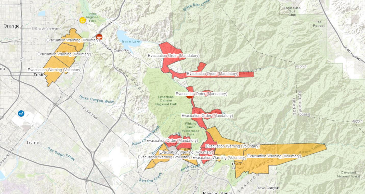
Road Closures:
- Santiago Canyon Road closed from Jackson Ranch Road to the 241 Freeway.
Evacuation Centers:
- Santiago Canyon College at 8405 E. Chapman Ave. in Orange. Because of the coronavirus pandemic, officials cannot establish an evacuation shelter, but they are providing people with vouchers to stay in hotels.
- The Orange County Emergency Operations Center has created a hotline for residents: 714-628-7085.
- Small pets can be taken to the Orange County Animal Care's Tustin facility at 1630 Victory Rd.
- Large animals are being accepted at the Anaheim Equestrian Center, 1370 S. Ave. in Anaheim, and at the OC Fair and Events Center, 88 Fair Drive in Costa Mesa.