Malibu Braces For Possible Mudslides In Woolsey Fire Burn Area
MALIBU (CBSLA) – With rain expected to hit Southern California Wednesday and Thursday, officials are bracing for possible debris flows, flooding and mudslides in Woolsey and Hill fire burn areas such as Malibu.
While the rainfall is expected to be light to moderate -- bringing anywhere between 0.3 to 0.7 inches of rain -- the hillsides and earth are so scorched in burn areas that the loosened soil and debris could potentially lead to dangerous rock and mudflows around slopes and foothills.
The best chance for rain is Wednesday night into early Thursday morning. The National Weather Service said there is a 30 percent probability that the upcoming rainfall will be sufficient to trigger debris flows in the Woolsey Fire and Hill Fire areas.
"Mud and debris flows "are a very realistic threat to the communities affected by the Hill and Woolsey fires. Due to an increased probability of mud and debris flows in these fire areas, it is important to plan and prepare," Woolsey Fire Unified Command said in a statement. "Evacuation orders should not be taken lightly, and are ordered because there is a threat to life and property."
Some fire-damaged areas remain unsafe, the electrical system is "extremely damaged," and road crews are working to clear rocks as emergency personnel prepare for the impending storm, Department of Public Works Director Mark Pestrella told the Los Angeles County Board of Supervisors.
Areas of concern include the Pacific Coast Highway and canyon roads in Malibu, as well as Malibu Creek. There is also concern about mud and rocks falling into the streets.
"We're going to have rock fall, we're going to have roads closed," Pestrella said. "The roads will not be safe to travel beginning Wednesday evening."
Pestrella said he expected PCH would be closed at some point.
To see the latest L.A. County road closures, click here.
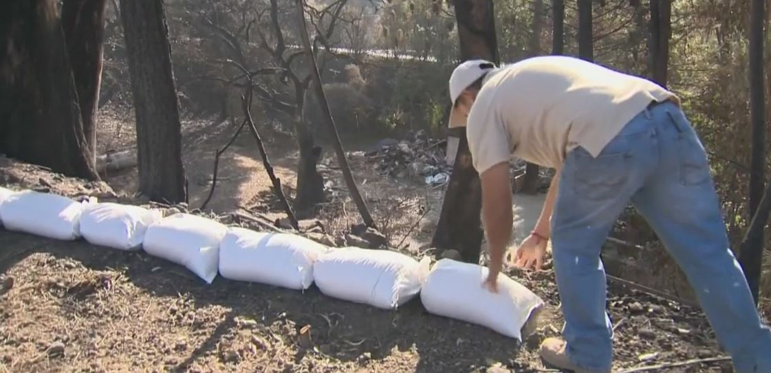
Recently evacuated residents who have just returned home in the burn areas have been preparing by picking up free sandbags at L.A. or Ventura County fire stations to help divert any potential flooding.
County and city agencies are monitoring debris basins in those areas to ensure they are filling up once the rain starts.
Though there are no immediate evacuation orders at this time due to the rain. Officials are asking residents to monitor, follow and respond to any emergency alerts.
"For most of the canyons, where they are when they come down to a point, where mud flow is going to come, they're going to take debris with it, they're going to take anything in its path along with it and bring that down, which is significant," L.A. County Sheriff's Department spokesperson Trina Schrader told CBS2 Wednesday morning. "So we want to be prepared and try to make sure that whatever areas those are, that we have K-Rails up, or that we have the people in those areas evacuate if need be. And we don't have any evacuation orders in place for anybody that's been repopulated as of this moment, but that could change later on today."
As of Wednesday morning, the Woolsey Fire was 96,949 acres in size and was 98 percent contained. The fire has destroyed at least 1,500 structures and damaged 341 others. Three people have been killed and three firefighters injured. Full containment, which had been slated for Monday, has been pushed back to Thursday.
The Woolsey Fire broke out around 2:30 p.m. on Nov. 8 in the area of Alfa Road and East Street, south of Simi Valley. On Nov. 9, it jumped the south side of the 101 Freeway at Chesebro Road near Calabasas and began spreading into Malibu.
COMPLETE COVERAGE: Woolsey Fire
Officials have gradually allowed residents to go home as utilities are restored and areas deemed safe.
Although the Pacific Coast Highway was fully open Wednesday, there were still several road closures north of the PCH, including Mulholland Highway, along with Malibu Canyon, Latigo Canyon, Encinal Canyon, Corral Canyon, Ramirez Canyon and Puerco Canyon roads.
At 10 a.m. Wednesday, the neighborhoods of Malibu and unincorporated Agoura along Kanan Dume Road -- north of Cavelleri Road and south of Triunfo Road -- were reopened to evacuees. Kanam Dume Road was fully reopened between the PCH and the 101 Freeway.
Meanwhile, there's also the possibility of mudslides in the burn area for the 4,531-acre Hill Fire, which broke out Nov. 8 and was fully contained Nov. 16. The blaze broke out Nov. 8 in the area of Hill Canyon and Santa Rosa roads in the Santa Rosa Valley, just west of California Lutheran University. Investigators believe it was human-caused.
Disaster Assistance Centers were opened to help residents affected by the blaze. They will be closed Thanksgiving but reopen Friday and Saturday from 10 a.m. to 6 p.m. They are located at the former Malibu Courthouse at 23525 Civic Center Way, and at the Conrad L. Hilton Foundation, 30440 Agoura Road, in Agoura Hills.
Residents with proper photo ID can pickup their mail at the USPS Facility at 7101 S. Central Ave. in downtown Los Angeles between 10 a.m. and 6 p.m. through Friday.
Malibu schools were expected to remain closed at least through the Thanksgiving weekend. Officials of the Santa Monica Malibu Unified School District said specialists will begin cleaning the schools so they are ready to reopen after the holiday.
Residents were urged not to try to restore their gas service but to contact SoCal Gas to do it. They also were cautioned to watch out for workers restoring services.
(© Copyright 2018 CBS Broadcasting Inc. All Rights Reserved. City News Service contributed to this report.)